


Editor's note: Find the latest forecast for the timing of storms in New Orleans here.
Two waves of severe weather are expected to move across Louisiana Monday and Tuesday, bringing heavy rain, strong winds and increased chances for flash flooding and isolated tornadoes.
Potentially damaging winds will arrive before the storms. Gusts of up 50 mph are possible in New Orleans, Baton Rouge, Acadiana and the Mississippi Coast Monday evening and into Tuesday. The wind could also cause power outages later in the evening.
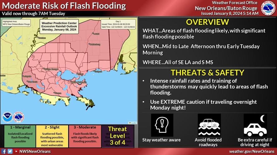
The National Weather Service in New Orleans and Baton Rouge predicts 3 to 5 inches of rain will fall across most of south Louisiana, and flash flooding is expected.
Together, the two systems are the largest severe weather event that Louisiana has faced in months, the NWS said Sunday night.
When will the bad weather hit your area? Here's a timeline for your city, as of Monday morning.

New Orleans metro
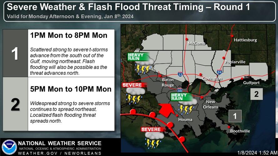
The worst of the first round of weather, which will bring thunderstorms and dangerous winds, is expected to arrive between 5 p.m. and 10 p.m.
The system will be moving from the south and will likely cause flash flooding as it moves north, the NWS said.
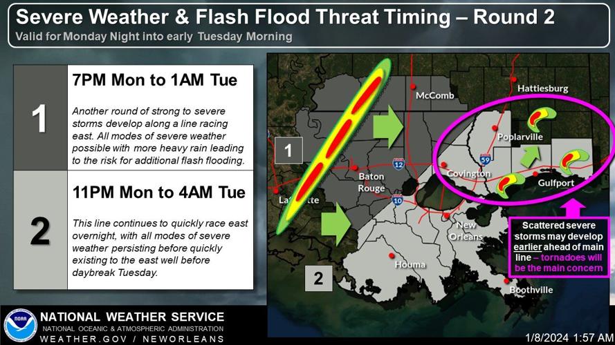
The second round of severe weather is expected to arrive between 11 p.m. Monday and 4 a.m. Tuesday. This line of storms will be moving quickly east.
The timing and threats will also affect the Northshore and Mississippi Gulf Coast at around the same times.

Baton Rouge, Acadiana
The first round of severe weather will move over Baton Rouge and parts of Acadiana earlier, with the worst conditions expected between 1 p.m. and 8 p.m.
In Baton Rouge, the second line of storms will produce more heavy rains and a possibility of flash flooding between 7 p.m. Monday and 1 a.m. Tuesday.
The Lafayette area could also feel some effects of the system around this time or earlier.

There's a 10% chance of tornadoes over much of southern Louisiana through 6 a.m. Tuesday. (National Weather Service)
Tornadoes possible on the northshore, Mississippi Coast
The National Weather Service said scattered thunderstorms are expected to pop up ahead of the second line of storms on the northshore and Mississippi Coast, and they could produce tornadoes and large hail.

Flash flooding
With 2 to 5 inches of rainfall expected across the coast, and locally higher amounts expected, flash flooding will be a significant concern with this system. There's a moderate risk, level 3 out of 4 for most of southeast Louisiana, including Lafayette, Baton Rouge and the New Orleans region. A slight risk, level 2, is possible for areas to the west, including Lake Charles.
A flash flood watch is in effect for southeast Louisiana, including Baton Rouge and New Orleans from noon Monday through 9 a.m. Tuesday.

High winds
Winds will be steadily increasing throughout the day on Monday, becoming strong and gusty at times in the afternoon through overnight. A wind advisory is in effect for southeast Louisiana from noon Monday through 6 a.m. Tuesday for winds of 20 to 30 mph, with gusts to 45 mph.
A high wind warning is in effect across coastal areas, with winds of 25 to 35 mph expected, with gusts up to 50 mph.

Coastal flood advisory
A coastal flood advisory is in effect for areas along Louisiana's southern and eastern coastlines. The warning also is in effect for northern Lake Pontchartrain, the western lake and Lake Maurepas, and for the southern Pontchartrain shore east of the levee system. Inundation of 2 to 4 feet can be expected, especially during the high tide cycle later Monday through Tuesday morning.
🌧️Here's how much rainfall you can expect tomorrow afternoon through early Tuesday morning. We're generally expecting 2-5 inches across the area with a potential band of locally higher amounts extending from SE LA and into S MS. pic.twitter.com/GKqNHNuTRR
— NWS New Orleans (@NWSNewOrleans) January 8, 2024
Most of the severe weather should be gone before daybreak Tuesday, but winds will be gusty throughout the day.
For the latest weather information, visit the National Weather Service's Facebook page.
