
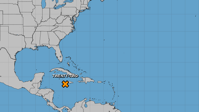
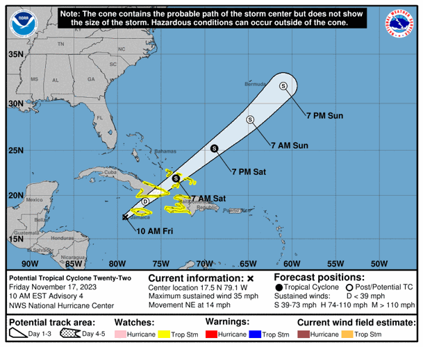


A disturbance over the Caribbean Sea could form into a tropical storm over the weekend as it continues to dump heavy rain on Jamaica and other parts of the Greater Antilles, according to the National Hurricane Center.
The trough of low pressure was located about 155 miles west-southwest of Kingston, Jamaica, Friday morning and was producing sustained winds of 35 mph. The system is forecast to continue heading northeast away from Louisiana.

A tropical storm watch was issued for Jamaica, Haiti, parts of Cuba, the southeastern Bahamas and the Turks and Caicos Islands, where the system is expected to bring heavy rain and possible flash flooding.
Though hurricane forecasters said the system's chances of becoming a tropical storm appear to be decreasing, it could still strengthen after crossing mountainous portions of Jamaica.
Low pressure near Florida
The National Hurricane center is no longer tracking a non-tropical area of low pressure that cropped up between southern Florida and the northwestern Bahamas earlier this week. It was not likely to form into a tropical depression or storm as it moves northeast into the Atlantic Ocean, forecasters said previously.
The busiest time of hurricane season
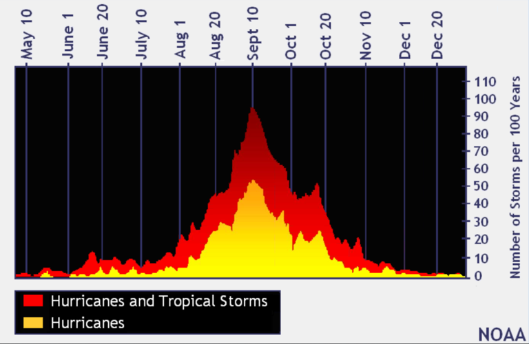
We've exited what is historically the most active period of the Atlantic hurricane season.

In the last 100 years, the tropics have been the most active in August, September and October, with Sept. 10 being the peak of the Atlantic hurricane season, according to federal forecasters. (graphic via NOAA)
In the last 100 years, the tropics have been busiest from mid-August through October, with Sept. 10 being the peak of the season, according to federal forecasters. About 80% of the systems that have hit the Gulf Coast formed during this time, according to the National Weather Service in Slidell.
The 2023 hurricane season
The return of El Niño was initially expected to bring a wetter second half of the year to Louisiana and a reduced risk of hurricanes.
The National Oceanic and Atmospheric Association's Climate Prediction Center announced March 9 that La Niña, which usually causes more hurricanes to form in the Atlantic, was officially over after an unusually long three years.
El Niño and its sister La Niña are part of the El Niño-Southern Oscillation cycle, a set of conditions over the Pacific Ocean that affects weather patterns across the world. In Louisiana, the biggest effects involve hurricane season in the Atlantic Ocean.
Regardless, this year's first cyclone hit in January, long before the official start of hurricane season, and June alone saw three named storms. Now forecasters are predicting that 2023 will prove to be an above-average hurricane season, with 18 named storms.
The first tropical storm to form in the Atlantic this year was named Arlene, reaching wind speeds of 40 mph on June 2 as it headed for Cuba. Don was the first storm to reach hurricane status in 2023, producing maximum sustained wind speeds of 75 mph on July 22 before rapidly weakening to a tropical storm the following day.
The next storm to form will be named Vince. Here's the full list of this year's storm names.
Don't miss a storm update this hurricane season. Sign up for our free Hurricane Center newsletter.