
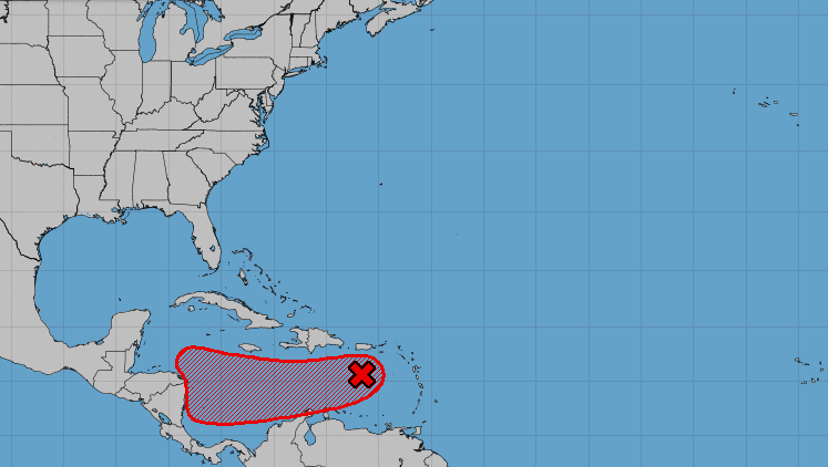


A trough of low pressure over the eastern Caribbean Sea is expected to move west toward Central America over the next several days, National Hurricane Center forecasters said Tuesday morning.
The system, which is producing a large area of showers and thunderstorms, is expected to move through conditions that could support further development. It has a 70% chance of forming into a tropical depression or storm within the next week, forecasters said, and is likely to bring heavy rains to Central America late this week.
While it's still unclear how the disturbance might impact the Gulf of Mexico, local meteorologists said last week that a strong cold front hitting Louisiana should stop the system from reaching the area.
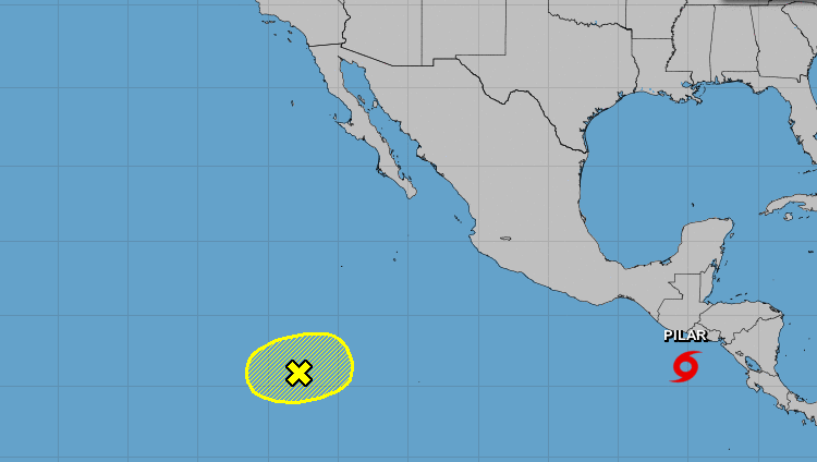
Systems in the Pacific
Tropical Storm Pilar is expected to bring flash and urban flooding to the Pacific coast of Central America, from El Salvador to Costa Rica, through Wednesday, according to the National Hurricane Center.

The system is moving east-northeast for now but is expected to make a southwestern turn away from the Gulf of Mexico later this week.
Another area of low pressure west of Central America is not likely to develop as it drifts northeast at sea.
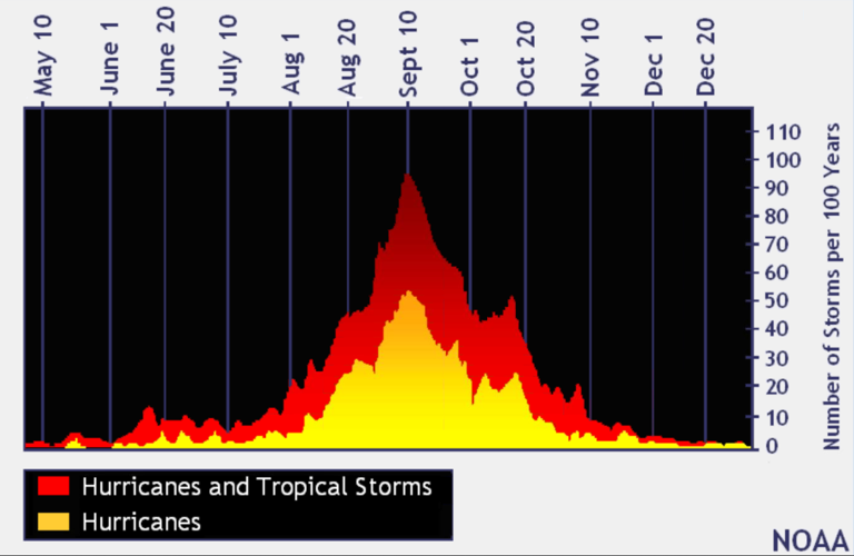
The busiest time of hurricane season
We're now exiting what is historically the most active period of the Atlantic hurricane season.

In the last 100 years, the tropics have been the most active in August, September and October, with Sept. 10 being the peak of the Atlantic hurricane season, according to federal forecasters. (graphic via NOAA)
In the last 100 years, the tropics have been busiest from mid-August through October, with Sept. 10 being the peak of the season, according to federal forecasters. About 80% of the systems that have hit the Gulf Coast formed during this time, according to the National Weather Service in Slidell.
The 2023 hurricane season
The return of El Niño was initially expected to bring a wetter second half of the year to Louisiana and a reduced risk of hurricanes.
The National Oceanic and Atmospheric Association's Climate Prediction Center announced March 9 that La Niña, which usually causes more hurricanes to form in the Atlantic, was officially over after an unusually long three years.
El Niño and its sister La Niña are part of the El Niño-Southern Oscillation cycle, a set of conditions over the Pacific Ocean that affects weather patterns across the world. In Louisiana, the biggest effects involve hurricane season in the Atlantic Ocean.
Regardless, this year's first cyclone hit in January, long before the official start of hurricane season, and June alone saw three named storms. Now forecasters are predicting that 2023 will prove to be an above-average hurricane season, with 18 named storms.
The first tropical storm to form in the Atlantic this year was named Arlene, reaching wind speeds of 40 mph on June 2 as it headed for Cuba. Don was the first storm to reach hurricane status in 2023, producing maximum sustained wind speeds of 75 mph on July 22 before rapidly weakening to a tropical storm the following day.
The next storm to form will be named Vince. Here's the full list of this year's storm names.
Don't miss a storm update this hurricane season. Sign up for our free Hurricane Center newsletter.